The Dodecanese
Ancient history, medieval castles and warm turquoise waters in the southeastern Aegean.
Where History Meets the Sea
The Dodecanese is an archipelago of the Aegean Sea with more than 160 islands and islets, mostly uninhabited. Its name means 'twelve (dōdeka) islands (nēsos)'.
The Dodecanese is home to vestiges of the Byzantine Empire, the Knights of St John, the Ottoman Empire and the Italian occupation of the 20th century, making it one of the most historically rich sailing destinations in the world.
The climate is mild with beautiful mountainous landscapes and stunning beaches. Rhodes' old town is a UNESCO World Heritage Site, while Patmos holds the Cave of the Apocalypse.
Dodecanese Islands
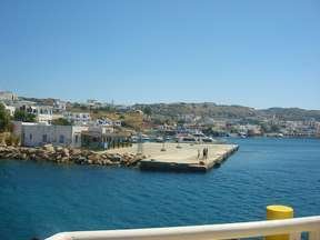
Rhodes
Rhodes is the largest Dodecanese island (1,400 km², 116,000 inhabitants) and one of the most famous in the world. In antiquity it was the site of the Colossus of Rhodes - a 32m bronze statue erected around 292 BC and destroyed by earthquake in 227 BC - the sixth Wonder of the Ancient World. The medieval walled Old Town is a UNESCO World Heritage Site. The interior is green and wooded, with the Valley of Petaloudes (Butterfly Valley) and the island's own breed of red deer.
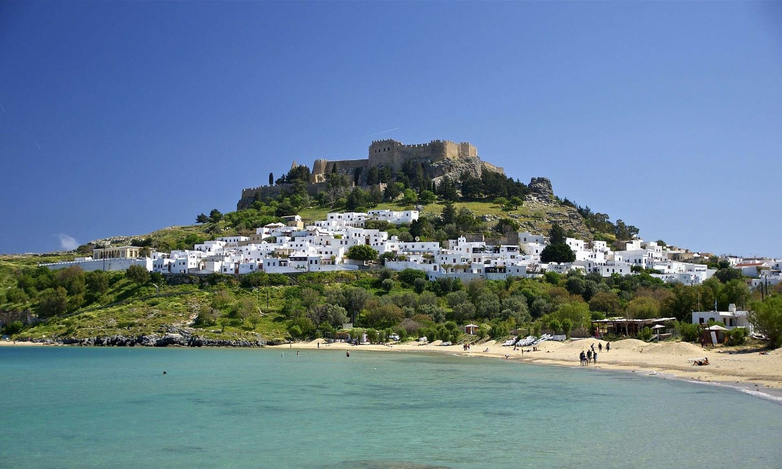
The Knights Hospitallers held the island from 1309 to 1523, leaving the magnificent Palace of Grand Masters and the Street of Knights. Lindos (55 km south) has whitewashed houses and a dramatic Acropolis on a 116m rock, reached by foot or donkey. Beaches: Vlycha, Ixia (8 km long), Kallithea Bay, Tsambika, Faliraki (5 km long), Prasonisi (wind/kite surfing), Lindos bay. Do not miss: The old walled city, the Palace of Grand Masters, Lindos Acropolis.
Kos
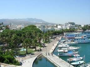
Kos (287 km², ~31,000 inhabitants) lies just 4 km from the Turkish coast, making it one of the most internationally connected Greek islands. The island is green, fertile and flat - ideal for exploring by bicycle. Kos Town features the Elefterias Square, the Neratzia Fortress (15th-century Knights Hospitaller fortification), the remarkable Hippocratic Plane Tree (said to be 2,400 years old, under which Hippocrates reputedly taught medicine), and the Gazi Hassan Pasha mosque (1786).
The Asklepiion (ancient hospital and sanctuary of healing) lies 4 km south of town on a wooded hillside. The mountain village of Zia offers an impressive sunset from its natural amphitheatre. Emporios has hot thermal springs reaching the sea at Therma Beach. Beaches: Paradise (Kefalos, most popular), Mastihari, Lambi, Kardamena. Do not miss: The Asklepiion, the Hippocratic Plane Tree, Zia at sunset.
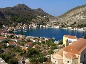
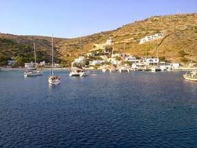
Symi
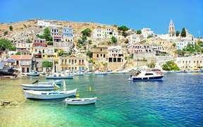
Symi (65.75 km², 2,560 inhabitants) lies about two hours by boat from Rhodes and is celebrated for its authentic charm, turquoise waters and upscale, unhurried atmosphere. The village is dominated by a Crusader fort and 500 steps of Kali Strata - lined with small pastel-coloured neoclassical houses in shades of amber, ochre and white. The capital has a clock tower and an interesting nautical museum.
The Monastery of Panormitis in the south of the island is the second most important in the Dodecanese, dedicated to the Archangel Michael and housing two excellent museums. Symi is surrounded by many small islets. Beaches: Pedi, Agios Giorgos, Agia Marina, Diavates - most accessible only by boat or on foot. Do not miss: The harbour, the Kali Strata steps, the Panormitis monastery.
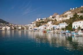
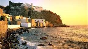
Patmos
Patmos (45 km², ~3,000 inhabitants) is known as the "Jerusalem of the Aegean" - it was here that Saint John wrote the Book of Revelation (the Apocalypse) during a period of exile. The imposing Monastery of Saint John the Theologian crowns the hilltop capital of Chora (3 km from the port of Skala). The upper town retains its 16th and 17th century Cycladic architecture. The Greek Parliament officially declared Patmos a "Sacred Island" in 1981.
The Cave of the Apocalypse - halfway between Skala and Chora - has been a UNESCO World Heritage Site since 1999. The island has around 20 beaches: Psili Ammos (the most beautiful, only accessible on foot or by caïque), Grikos, Diakofti, Kampos. Do not miss: The monastery, the Cave of the Apocalypse, the old town of Chora, the beach of Psili Ammos.
Kalymnos
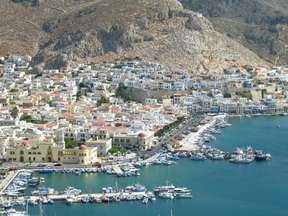
Kalymnos (110.58 km², mountainous, 12 km north of Kos) has been world-famous for over 500 years for its sponge fishermen, who dived throughout the Mediterranean and North Africa. Today the island thrives on tourism and rock climbing - it is one of the world's top climbing destinations, with limestone crags overlooking the sea. Pothia (the capital and port) has colourful neoclassical houses, the Metropolitan Church of Christ, an archaeological museum and a nautical museum.
The ancient capital Chorio has the imposing Paleochora Castle (11th century Byzantine, later used by the Knights of Saint John). Myrties and Massouri on the west coast face the island of Telendos and have the best beaches. Vathy to the east is an authentic fishing village in a dramatic fjord-like bay. Emborios in the far north has quiet pebble beaches and a timeless feel.
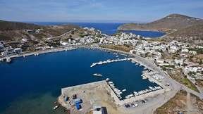
Leros
Leros (53 km², ~8,000 inhabitants) is small, green, mountainous and refreshingly authentic. Its landscape and architecture are dominated by its period under Italian rule (1912-1943) - wide Art Deco boulevards, rounded façades and public buildings in Fascist Rationalist style give Lakki the feel of a southern European city transplanted to the Aegean. The capital Platanos, with the neighbouring villages of Agia Marina and Panteli, has a completely different, typically Greek character.
The 11th-century Byzantine fortress towers above the capital. There is a sailing school in Lakki and excellent scuba diving at Xerokampos. The War Museum in the old Merikia tunnel covers the Battle of Leros in 1943 (one of the last major German-Allied battles of WWII). Beaches: Alinda, Agia Kioura (blue lagoon-like waters), Gourna, Pandeli (pebble, crystal clear).
Karpathos

Karpathos (324 km²) lies between Crete and Rhodes and is the second largest island in the Dodecanese, with about 7,000 inhabitants. Together with Saria (to the north) and Kassos (to the southwest) it forms a small archipelago. The traditional village of Olympos, perched at 250m altitude in the north, is renowned for its medieval architecture and inhabitants who still wear traditional costumes to this day.
Apella beach has been named one of the most beautiful in the entire Mediterranean - fine pebbles, crystal-clear water framed by white cliffs and pine trees. The main town is Pigadia on the southeast coast, with a 4km sandy beach. Other beaches: Kyra Panagia, Achata, Lefkos, Finiki, Arkassa. The north of the island is reached by boat or via a challenging mountain road - pristine and wild. Do not miss: Apella beach, the village of Olympos.
Astypalaia
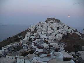
Astypalaia (114 km², ~1,200 inhabitants) has a distinctive butterfly shape and occupies a unique position - geographically and culturally exactly between the Dodecanese and the Cyclades, feeling like a blend of both. Chora, the capital and port, is one of the most picturesque in the entire Aegean: a Venetian citadel crowns the hilltop, and the traditional two-storey houses with their typically blue-painted shutters cascade down the slopes below.
Livadia is a smaller seaside village 2km from Chora with vineyards, mandarin orchards and a beautiful beach. Analipsi (Maltezana), 9km from Chora, was once a haunt of Maltese pirates. Vathy is a charming fishing village in a deep fjord-like inlet, with calm beaches and the nearby Dragon Cave (stalactites). Do not miss: Chora village, Livadia bay, Vathy inlet, the viewpoint from the Venetian castle.
Halki
Halki (37 km², only 280 inhabitants) lies 6 km west of Rhodes but feels a world away from its tourist-filled neighbour. Very mountainous and very authentic - no mass tourism exists on Halki. The capital and only port, Nimborio, has a beautiful neoclassical architecture arranged theatrically in an amphitheatre around the port. The ancient capital (Chora) is abandoned and medieval, with ruins of a castle built on an ancient acropolis.
The Church of Agios Nikolaos has remarkable mural paintings. Monasteries include Taxiarche Archangel Michael, Ai-Yiannis, Agia Triada and Stavros. The neighbouring uninhabited islet of Alimia has sandy beaches and is reachable by boat. Pandamos is the island's main beach - clean, pebble and uncrowded. Do not miss: Walking to the ghost village of Chora, the church of Agios Nikolaos, the boat trip to Alimia.
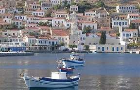
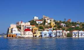
Kastellorizo
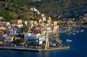
Kastellorizo (9 km², ~300 inhabitants) is the easternmost island in the Mediterranean - just 7 km off Kaş on the Turkish coast and 130 km east of Rhodes. Its bay is one of the most beautiful in Greece: a perfect horseshoe harbour surrounded by tall neoclassical coloured houses reflected in the turquoise water, guarded by the ancient Kastell Rosso - a fortress built by the Knights of Saint John on blood-red rocks that give the island its name.
The single village of Megisti has an excellent archaeological and folklore museum. The Church of Agios Konstantinos (built in 1835) is partly constructed from columns and marble of an ancient Apollo temple. There are no beaches but the surrounding seas have extraordinarily clear, crystalline water. The Blue Cave on the north coast (accessible by boat only) is famous for its multicoloured light refractions in the stalagmite-adorned chamber. Do not miss: The harbour, the Blue Cave, the castle.
Nisyros
Nisyros (41 km²) is almost perfectly circular and shaped by the forces that made it - it is an active volcanic island, the youngest volcano in the Aegean, with its last major eruption in 1887. The central crater, Polybotes (260m diameter, 30m deep), is accessible by steps and is surrounded by yellow sulphur deposits, steam vents and an otherworldly smell. Greek mythology says Poseidon trapped the giant Polyvotis under this rock when it was hurled from Kos - creating the island.
The capital Mandraki (northwest coast) has charming white and brightly coloured houses, a dramatic clifftop Venetian castle, and a folklore museum. The mountain village of Nikia sits at 400m on the crater rim with the most spectacular views and a perfect round plateia. The Monastery of Panagia Spiliani is carved into the rock face of the castle. Beaches: sandy Mandraki, volcanic black-pebble Cholchaki, Agia Irini, Palos.
Tilos
Tilos (65 km², ~780 inhabitants) lies between Nisyros and Chalki. It is an island for nature lovers - the Tilos Park covers much of the island and protects impressive indigenous flora and fauna, including rare birds. The island has two main villages: Megalo Chorio (the inland capital, with a Venetian and Knights Hospitaller fortress) and Livadia (the main port, with a beautiful pebble beach and crystalline waters).
Charkadio Cave is famous for its 70,000-year-old fossilised elephant and deer bones (a small adjacent museum displays the finds). The Monastery of Agios Panteleimon (15th century, abandoned) has the best sunset on the island. Micro Chorio - a village of 200 abandoned houses - is illuminated at night by solar power. Eristos is the largest and most beautiful beach. Do not miss: Charkadio Cave, hiking to Agios Panteleimon, Eristos beach.
Lipsi
Lipsi (16 km²) is green, authentic and largely car-free. Legend says this is the island where Ulysses lived with the nymph Calypso for seven years before continuing his odyssey home. Lipsi is the main island of a mini-archipelago of 25 small islands and islets, most uninhabited. The town has blue-domed churches, narrow alleys and a small but interesting museum.
Kimissi Mountain has a 16th-century church dedicated to the Virgin Mary. The Vroulidia Bay area is a protected nature reserve in progress. Beaches: Platis Gialos (the most popular, sandy, sheltered bay, crystal clear water), Katsadia (sandy, on the south coast), Koklakoura (large bay, pebble beach reachable on foot). The ferry connection to nearby Patmos makes it easy to combine the two islands in one itinerary.
Kassos

Kassos (69.46 km², ~1,000 inhabitants) is the southernmost island of the Dodecanese - a remote, unspoilt island mentioned in Homer's Iliad, whose inhabitants fought in the Trojan War. Far from the tourist trail, Kassos has been historically an island of ship owners and merchants rather than of tourism. The island has a proud maritime heritage. The capital and port Fri has picturesque stone houses and numerous churches.
The ancient capital Poli retains the remains of a Venetian citadel and the church of Agia Triada. Ellinokamara caves show evidence of Neolithic settlement. The Monastery of Agios Georgios in Chadies is reached by a short hike. Arvanitochori is the only green valley on the island. Beaches: Helathros and Ammouda are the most beautiful - uncrowded, pristine. The uninhabited islet of Armathea is reachable by boat.
Agathonisi
Agathonisi is a tiny island at the northern tip of the Dodecanese, covering just 13.5 km² with around 160 permanent inhabitants. It has two small villages: Megalo Chorio (where most residents live) and Mikro Chorio. The port of Agios Georgios is the island's gateway. Agathonisi is quintessentially off-the-beaten-track - completely free from mass tourism, unhurried and peaceful.
Small, isolated coves with crystal-clear water are scattered around the coastline, most accessible only by boat. Interesting Byzantine buildings from the 11th century ('domes' amid the scrubland) testify to the island's ancient habitation. Two grocery stores, a handful of rooms and a couple of taverns serving fresh fish - everything you need. The surrounding uninhabited islets of Glaros, Kounéli, Nera and Psathonísio are perfect for day anchorages.
Arkoi & Marathi
Arkoi is a tiny Dodecanese island in the municipality of Patmos with only 44 permanent inhabitants. The landscape is rocky with olive trees, low shrubs and small churches. The community survives on fishing and goat-breeding. An Italian fortress, small caves and a handful of tiny churches dot the shoreline - the most beautiful, Panagia, has a spectacular view over the sea.
Tiganakia is the most beautiful beach on Arkoi - a sheltered cove with transparent turquoise water protected from the winds by rocks on all sides. Limnari and Padelia are also worth visiting. The nearest inhabited neighbour is Marathi - a tiny rocky island just minutes away by boat, with a single restaurant, about 10 simple rooms, a church and no roads or cars. For anyone who wants total isolation, Marathi is extraordinary.
Pserimos
Pserimos (14.6 km², ~130 inhabitants) lies 14 km from Kos in the strait between Kos and Kalymnos. It is a genuinely quiet island with no big hotels and no cars. The single village is built around a beautiful white sandy beach - one of the best in the Dodecanese. A beautiful small church looks out over the bay, and fresh fish restaurants line the waterfront.
Visiting yachts anchor in large numbers along the superb sandy bay. The island also receives daily excursion boats from Kalymnos and Kos, but remains low-key compared to its neighbours. Beaches: Avlakia, Trevathia, Roussa, Vathi, Marathontas, Korakia, Glistra - all uncrowded and clean. An international scout camp is held here each year. Do not miss: The main beach, the fresh fish at nightfall, the peaceful evening after the excursion boats leave.
Sail the Dodecanese
Let our specialists build your perfect Dodecanese itinerary.